


HISTORY OF THE TRAIL
In the late 1980's and early 1990's, a group of resort owners and others began discussing the possibility of constructing a recreational trail to provide a safe corridor for bicyclists, in-line skaters, joggers and walkers along Highway 61, paralleling the North Shore of Lake Superior. Originally the scope of the trail was confined to the Tofte-Schroeder-Lutsen area.
When the Minnesota Department of Transportation (MnDOT) agreed in 1996 to support the idea of a separate trail for the North Shore, the proponents of the trail officially organized as the North Shore Touring Trail Association (NSTTA), and the proposed trail was to be named the North Shore Trail. In 1999 the NSTTA voted to change the name of the trail to the Gitchi-Gami State Trail (GGST) and the name of the organization to Gitchi-Gami Trail Association (GTTA). Today the GGTA is an all-volunteer, self-sufficient 501 (c) (3) non-profit organization with a Board of Directors, which meets regularly.
The GGTA works closely with the Minnesota Department of Natural Resources (DNR) and MnDOT in trail design, construction and maintenance. The GGTA also oversees trail activites, including the Annual Ride, and the promotion of the trail. There is no charge to use the trail, but all who enjoy using it are encouraged to join the GGTA to support its efforts.
The GGTA is fortunate to be able to partner with the Arrowhead Regional Development Commission (ARDC) for administrative services and other assistance. We have contracted with Michelle Pierson, ARDC project assistant, to serve as the GGTA executive director.
PROGRESS OF THE TRAIL
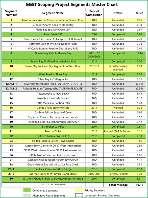
Completed segments of the GGTA currently total over 29 miles.The longest completed section is the 14.1-mile segment between Gooseberry Falls State Park northeast to the town of Beaver Bay.You can consult the trail map for details.
The first comprehensive overview of the existing trail and the proposed trail corridor -- the GGST Scoping Project -- was prepared for the GGTA by Charlie Moore, Regional GIS Specialist for the ARDC, and completed in 2016. The project was funded in part by the Coastal Zone Management Act, and NOAA's Office of Ocean and Coastal Resource Management, in conjunction wiith Minnesota's Lake Superior Project. For planning purposes, the trail was broken into 30 segments, and grouped into completed segments, priority segments, and long-term planned segments, with a detailed corresponding map for each. A large database of information was gathered. For each incomplete segment, the report includes the estimated length, estimated cost of construction and engineering, benefits of completing the segment, challenges and barriers (including bridges and underpasses needed), unique opportunities, and next steps.
The master chart below shows each of the completed, priority, and long-term planning segments.The entire Scoping Project report, including maps of each segment, can be accessed online.